Making Wireless IoT Project Easy, Smart, Secure.
GET A FREE SAMPLEWhen there is a fire accident in an urban building, it is very unsafe for firefighters to enter the fire scene. During the rescue process, leaders cannot know the real-time location of firefighters. Once the firefighters encounter an emergency, others cannot rescue the firefighters in time.

In order to solve the location problem of fire rescue personnel, SKYLAB has developed a fire UWB personnel positioning system. Firefighters wear UWB positioning tags to enter the rescue scene. The commander can grasp the real-time location information of firefighters in real time. UWB personnel positioning system can improve the command ability of field leaders.

The system adopts 1+N method. 1 central node includes vehicle-mounted long-distance receiving UWB base station or Bluetooth gateway. N UWB positioning tags, which are carried by rescuers. At the same time, it is also possible to realize the mutual network positioning of N UWB positioning tags. Display the mutual position and distance on the terminal screen.
The UWB base station obtains the location information and alarm information of all UWB positioning tags. Through analytical modeling, commanders can obtain relative and absolute positions of UWB tags. Provide location basis for personnel scheduling.
Each UWB positioning tag can be networked with N nearby UWB tags to locate each other. The location information of the tag bar is sent back to the UWB base station and the control and dispatch center.
In addition, after the UWB tag triggers SOS for help, it can notify three nearby rescuers carrying UWB tags to come to support. Rescuers can use the PDOA angle measurement + TWR distance measurement method to measure the angle and distance of the alarmed UWB tag, and then go to support.

The UWB base station is equipped with a Beidou high-precision positioning module, which can update its absolute position in real time.
The surrounding three fixed-point tags can be fixed around the base station. For example, if you put it on the car, you can follow up the positioning tag in real time to obtain the best positioning effect.
The static accuracy of Beidou positioning is as high as 10cm, and the accuracy of UWB ranging positioning is also 10cm. The combined accuracy can achieve a circular error of 20cm.
The dynamic accuracy is related to the ranging frequency of the UWB tag and the background processing speed. Generally, the accuracy of less than 50cm can be achieved.
UWB belongs to the communication technology in the short and medium range, which is very suitable for indoor real-time positioning system.
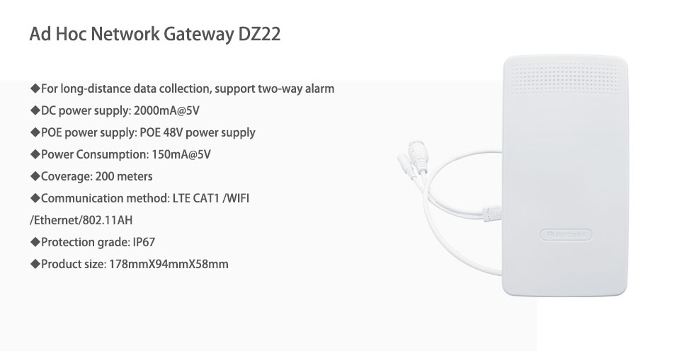
At present, the coverage distance of UWB base stations can reach 200 meters. It also supports extended power to extend the coverage distance.
UWB signal has strong penetration when using low channel CH2. The penetration is between 2.4G WiFi and 5G WiFi.
UWB signals can pass through concrete, glass, wood, etc. It can maintain better signal integrity and is less affected by the medium. Therefore, the accuracy of the coordinate position calculated based on this model is relatively high.

The main functions of the UWB positioning system software platform include: system settings, personnel management, attendance management, location monitoring, health monitoring, etc.
Administrators can operate some general settings of the system. Including account management, map management two parts. Account management is mainly about adding, deleting, modifying, querying information, and assigning permissions to system visitors. Map management involves users importing new location maps. Switching query of maps of different places, adding or modifying map information;
The system can manage the positioning personnel uniformly. Including monitoring personnel location changes, collecting information on the environment where personnel are located, and grouping personnel for management. The system can also set a specific person as the key monitoring object of the system.
Functions that need to be used in some common application scenarios. Regularly need to call the resources in the system uniformly, alarm for absenteeism, etc.
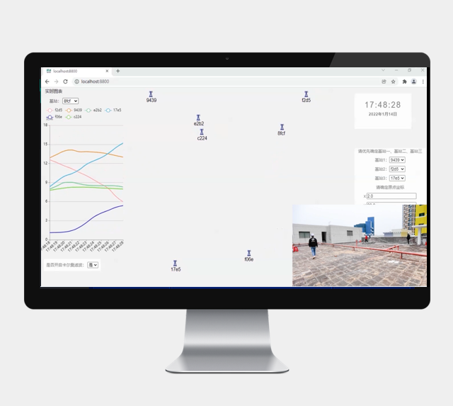
The system provides a real-time view of the location of each person. Mark its offline or online status, record and playback its movement track, etc. Electronic fences can be set to monitor the location.
UWB tags can collect vital signs data of the person wearing them. Such as heart rate, blood oxygen, body temperature, etc. In addition, UWB tags have SOS active alarm function. In an emergency, the wearer can use the UWB tag to actively call the background.
Prev:Bluetooth Beacon Asset Location Tracking Solution Manufacturer
Next:Application of Bluetooth Beacon Indoor Positioning in Shopping Center
Copyrights© Shenzhen Skylab Co.,LTD All Rights Reserved.


