Making Wireless IoT Project Easy, Smart, Secure.
GET A FREE SAMPLEIn hospitals, disease control centers and other places, a comprehensive disinfection and sterilization is required. Doing a good job of virus prevention and control disinfection can effectively prevent and interrupt the spread of virus. Prevention and control is greater than treatment, disinfection work in the first place. In the process of hospital spray disinfection, it is impossible to determine whether personnel have done a comprehensive disinfection of the premises.
SKYLAB has developed and launched a spraying and disinfection detection and personnel Bluetooth positioning system. The personnel positioning and disinfection detection system is based on Bluetooth technology development. The personnel positioning accuracy is 3~5 meters. It allows real-time accurate positioning of personnel to ensure that they have visited all areas that need to be disinfected. Managers can detect the effect of the spraying in real time.
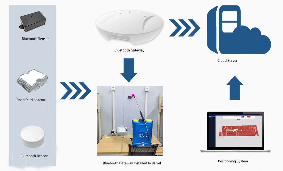
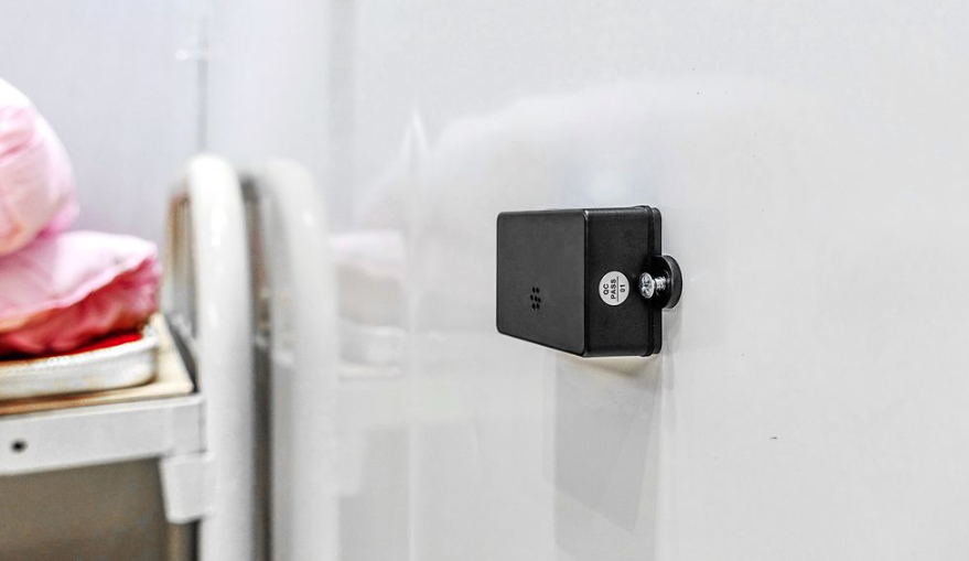
Bluetooth beacons have built-in temperature and humidity sensors. SKYLAB beacon VDB1611 complies with both iBeacon and Eddystone Bluetooth broadcasting protocols. It can broadcast the movement status, temperature and humidity information in real time. The sensor beacon samples the temperature and humidity in the surrounding environment once a minute. It acquires the corresponding data and broadcasts the temperature and humidity data collected by the sensor in real time.
The 4G Bluetooth gateway VDB2602 in the extermination sprayer scans the surrounding Bluetooth sensor signals. It transmits it to the designated cloud server through 4G network. The system decodes the current location information of the extermination sprayer.
The Bluetooth beacon sensor supports modification of both ibeacon and Eddystone working modes. It can modify broadcast frequency, power, UUID, Major, Minor, etc., parameters through mobile APP.
The Bluetooth gateway in the exterminator sprayer scans the data packets back to the designated cloud platform. It achieves structured data management and standardized storage through standardized conversion.
.jpg)
4G Bluetooth gateway scans and collects the broadcast information of Bluetooth sensors.
The Bluetooth gateway sends the collected humidity data, location information and extermination results to the CLE positioning server.
The system platform can monitor the usage of disinfection solution in real time. It can present the summary of disinfection data and data breakdown by means of statistical reports. It supports manual synchronization and editing of data. It supports exporting Excel, PDF and other formats. It is convenient for managers to manage the data effectively.
Bluetooth positioning system can show the situation of extermination data in real time. Including the movement track of extermination personnel, extermination time, and combined with humidity data to determine whether it is effective extermination.
Extermination system can add/modify/delete information corresponding to the extermination sprayer, maintain the name of personnel and other information.
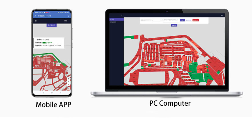
The Bluetooth positioning system provides indoor or outdoor vector maps. It displays the distribution of each floor in the hospital in equal proportion according to the actual area and pattern. And you can mark each extermination and cleaning partition in the map.
In the vector map, you can display the current extermination status of each extermination partition in real time. Different colors are used to distinguish the most recent extermination time of each extermination partition. If the last extermination is within 30 minutes from the current one, the extermination partition is shown in green on the map. If it is 30-60 minutes from the current time, it is shown in yellow. If it is more than 60 minutes from the current time, the map will be red. You can select one of the extermination zones to display its last extermination time.
The system can calculate the real-time location of the personnel wearing the extermination bucket in real time. Managers can query in real time according to the floor map and the extermination bucket number. Personnel location information can be presented in the map in real time.
The system can provide the query page of the extermination record. Managers can filter the query according to the extermination partition number and the time of extermination. The page can record each extermination record, including: the name of the extermination partition, the start time of extermination, and the end time of extermination.
Copyrights© Shenzhen Skylab Co.,LTD All Rights Reserved.


