
Making Wireless IoT Project Easy, Smart, Secure.
GET A FREE SAMPLEIn urban canyons, underground parking garages, long tunnels, and other environments where satellite signals are weak or completely lost, traditional vehicle navigation often suffers from position drift, speed jumps, and heading confusion. For professional applications such as autonomous driving test vehicles, high-definition mapping vehicles, public transit dispatching, and precision agriculture, this "loss of signal" not only degrades user experience but can also cause complete system failure. How can vehicles achieve continuous, reliable high-precision positioning in any scenario? The SKM2505NRD-40MXT dual-band RTK INS high-precision Gmouse provides a compelling answer: it deeply integrates L1+L5 dual-band RTK positioning with inertial navigation technology. Even without any odometer signal, it can independently output centimeter-level position, velocity, and attitude information for extended periods after satellite signal loss, achieving truly "all-weather, all-scenario" high-reliability navigation.
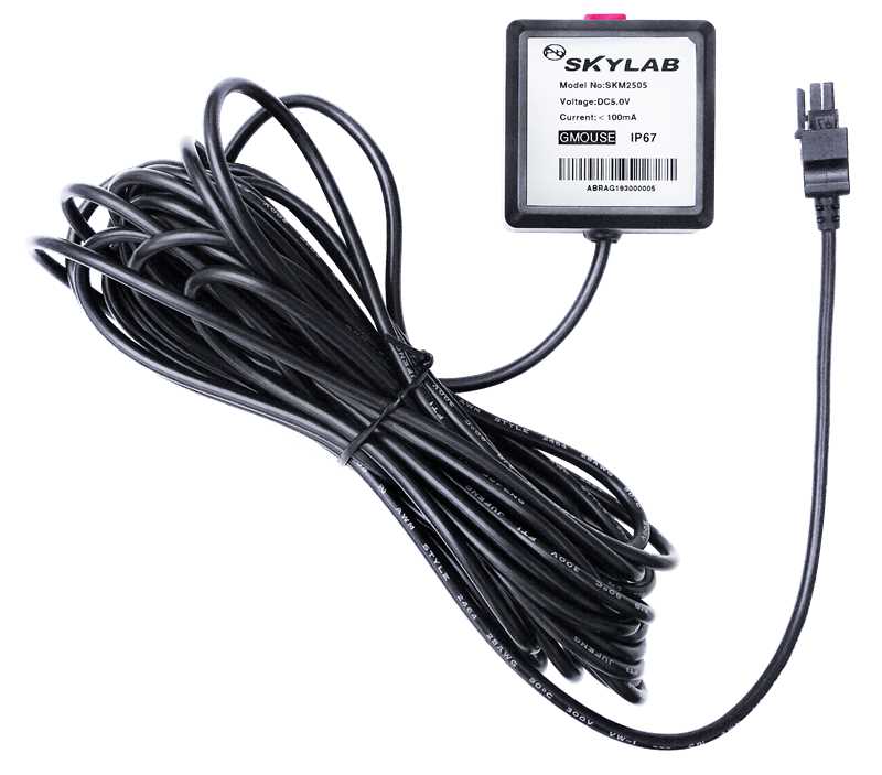
The SKM2505NRD-40MXT completely eliminates the need for odometer integration through dual-band RTK + high-performance MEMS inertial sensors + adaptive Kalman filtering, significantly improving positioning continuity in weak-signal and no-signal environments.
The module integrates a high-sensitivity dual-band GNSS receiver supporting GPS L1/L5, BeiDou B1I/B2a, Galileo E1/E5a, QZSS L1/L5, and includes a built-in dual-band high-precision antenna. In RTK mode with differential data input, it achieves horizontal positioning accuracy of ≤1 cm + 1 ppm, meeting the stringent requirements of high-precision mapping, autonomous driving, and precision agriculture.
The module integrates a 3-axis gyroscope and 3-axis accelerometer, with factory calibration for orthogonal errors, temperature drift, and other biases. When GNSS signals are completely lost (e.g., entering a tunnel), the system automatically switches to pure inertial navigation mode. Without any external odometer signal, it continues to output position, velocity, pitch/roll/heading angles for extended periods using only its own inertial solution. Real-world test data shows: within 120 seconds of GNSS loss, horizontal position error is approx. 60 meters, horizontal velocity error 0.5 m/s, and heading error 2.0 degrees – a leading performance among similar global products.
Based on an Extended Kalman Filter (EKF) tightly coupled architecture, the system evaluates GNSS signal quality in real time and dynamically adjusts the weighting between satellite and inertial data. In open areas, it fully trusts GNSS; in partially obstructed areas, it increases INS weighting; and during complete signal loss, it relies entirely on INS. The algorithm also detects and rejects GNSS data with significant errors (e.g., multipath reflections), effectively suppressing position jumps and drift.
For stop-and-go scenarios such as traffic lights or jams, the algorithm detects zero-velocity states via the accelerometer and corrects velocity integration errors to prevent position drift. Additionally, adaptive filtering effectively removes high-frequency vibration accelerations during driving, ensuring smooth velocity and attitude outputs.
The module features a compact, integrated design (built-in antenna and IMU) and can be mounted at any angle on the roof or near the dashboard. After power-up, a static period of 5–10 seconds completes attitude initialization; then a few minutes of normal driving (including acceleration, deceleration, and turns) enables automatic installation angle recognition and calibration. It adapts to cars, trucks, buses, agricultural machinery, etc.
The module provides a UART interface with RS232 levels, default baud rate 115200, outputting standard NMEA0183 sentences (including GGA, RMC, GSV, etc.). It also outputs extended sentences:
$PAIRMSG,90* – INS status (0=unknown, 1=initializing, 2=coarse, 3=stable)$PAIRMSG,91* – dynamic status and driving behavior alerts (e.g., hard acceleration, hard braking, sharp turning, collision)Urban buses frequently travel under viaducts, tree-lined roads, and tunnels. Field tests in Shenzhen’s Henglongshan Tunnel and an underground garage show that after 100 meters of pure inertial navigation, the error is only 1–2 meters – perfectly solving the "lose signal in tunnels" problem.
RTK centimeter-level positioning meets lane-level guidance requirements, while INS fills in signal gaps in urban canyons, ensuring continuous, complete trajectories for mapping vehicles.
Mounted on tractors or harvesters, the module continues positioning with INS in areas where RTK signal is weak (e.g., field edges), achieving row spacing errors <5 cm.
Real-time acquisition of vehicle position, velocity, acceleration, and yaw rate enables driving behavior analysis (hard acceleration/braking/turning), providing data support for fleet management and usage-based insurance pricing.
The SKM2505NRD-40MXT is an all‑in‑one terminal integrating a dual‑band high‑precision GNSS antenna and an IMU.
No more fear of tunnels and skyscrapers – empower every vehicle with navigation that never gets lost.
The SKM2505NRD-40MXT dual‑band RTK INS high‑precision Gmouse redefines the reliability of vehicle navigation through integrated positioning technology. It allows autonomous driving test vehicles to maintain lane‑level positioning in long tunnels, prevents bus position jumps under viaducts, and enables precision agricultural machinery to continue working at field edges. Choose it – choose a positioning confidence without blind spots.
Prev:Timing module: the "time engine" that concerns the lifeline
Next:UWB Positioning Solution for Immersive Experience Halls
Copyrights© Shenzhen Skylab Co.,LTD All Rights Reserved.


