Making Wireless IoT Project Easy, Smart, Secure.
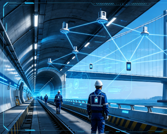
GET A FREE SAMPLEIn linear, complex, and high-risk construction and O&M scenarios such as a 4-kilometer tunnel and a 2-kilometer bridge, personnel safety management faces unprecedented challenges. Inside the tunnel, GPS signals are completely lost, the environment is dim, and the structure is complex. On the bridge section, although outdoors, the demand for high-precision positioning is equally urgent. Traditional management methods have fatal blind spots: "cannot see, cannot manage, cannot rescue in time."
Leveraging proven UWB (Ultra-Wideband) indoor positioning and RTK (Real-Time Kinematic) satellite positioning technology, this integrated UWB+RTK personnel positioning solution is purpose-built for long-distance tunnel and bridge projects. It achieves full-process, seamless, centimeter-level personnel location tracking and proactive safety control—from deep inside the tunnel to the top of the bridge.
A single technology cannot cover the full tunnel-bridge scenario. Fusion positioning is the inevitable choice:
◆ Inside the Tunnel (UWB Dominant): The UWB system uses a TDOA positioning algorithm and deploys positioning anchors along the tunnel walls to form a continuous positioning network. With extremely high accuracy of 10–30 cm, it can precisely determine which ring and side of the tunnel a person is on, and even whether they are approaching a hazardous work face. UWB signals offer strong anti-interference capabilities, effectively overcoming multipath effects caused by metal supports and machinery inside the tunnel.
◆ On the Bridge and in Open Areas (RTK Dominant): RTK base stations are deployed outside the bridge and tunnel entrances to provide differential correction signals for the UWB+RTK fusion positioning tags worn by personnel, achieving outdoor centimeter-level satellite positioning. This perfectly solves the problem of ordinary GPS accuracy (meter-level) being insufficient on bridges.
◆ Seamless Switching and Fusion Positioning: The positioning tag incorporates intelligent algorithms. When a person moves from outdoors into the tunnel, the system automatically and smoothly switches from RTK mode to UWB mode, ensuring uninterrupted position data, and vice versa. This truly delivers an "indoor-outdoor integrated centimeter-level positioning service."
The entire system forms a stable and efficient safety IoT network.
For the "4km tunnel + 2km bridge" requirement, the recommended equipment configuration is as follows:
1. Positioning Sensing Devices (Hardware Layer):
◆ UWB Positioning Anchors: Used for full coverage inside the tunnel. Depending on the tunnel structure (straight/curved) and the anchor coverage radius (typically 50–100 meters), approximately 80–100 explosion-proof/industrial-grade UWB anchors are needed for dual-side deployment in a 4km tunnel. A small number of anchors are also required at the bridge-end entrances to cover the positioning mode handover zones.
◆ RTK Base Stations: For outdoor high-precision positioning. Deploy 1–2 RTK base stations in open locations near the bridge or the project command center to provide differential signals for the entire outdoor work area.
◆ UWB+RTK Fusion Positioning Tags: Issued to every construction, management, and inspection worker. The card integrates UWB and RTK dual-mode chips and features SOS one-key alarm, motion detection, and low power consumption.
◆ Personnel Tag Issuing Machines (2 units): Deployed at the main entrances of the tunnel/construction site for rapid issuance, recovery, information binding, and permission setting of positioning tags, enabling highly efficient digital management of personnel entry and exit.
2. Positioning Computing Core (Engine Layer):
◆ UWB Positioning Engine: An independently developed high-precision TDOA algorithm engine that calculates the coordinates of all UWB tags in real time.
◆ Location Fusion Engine: Responsible for processing UWB and RTK position data, performing intelligent filtering, smoothing, and fusion to output a unified, continuous, and accurate personnel location stream.
3. Safety Management Center (Platform Layer):
◆ Personnel Positioning Management Platform: Displays the real-time location, identity, and status of all personnel on the large screen in the project command center and on the computers/mobile phones of managers at all levels, using an electronic map (can be integrated with a tunnel BIM model).
◆ Core Functions: Include real-time positioning, historical trajectory playback, electronic geo-fencing (setting up protection for dangerous areas such as the tunnel face and bridge edges), zone breach alarms, SOS emergency alarms with video linkage, personnel attendance statistics, and more.
1. Real-Time Location Visibility, Eliminating Safety Blind Spots
The command center can grasp the precise position and distribution of every worker in the tunnel and on the bridge at any time, achieving a "single global map" and completely changing the previous "loss of contact" status once personnel enter the tunnel.
2. Proactive Warning for Hazardous Areas
Set up electronic geo-fences at the tunnel face, high-risk support sections, near transformers, and at bridge edges and high-altitude work areas. Once unauthorized personnel enter or stay overtime, the system immediately triggers on-site audible/visual alarms plus platform pop-up warnings, enabling proactive prevention.
3. Emergency Search & Rescue and One-Key SOS
When a worker is in danger, pressing the SOS button on the positioning tag immediately locks their precise location (both indoors and outdoors) on the platform, pops up their recent activity trajectory, and can simultaneously link and retrieve nearby surveillance video, greatly enhancing the response speed and accuracy of emergency rescue.
4. Operation Standardization and Attendance Management
Standard inspection routes can be set to supervise whether inspectors are in place. The system automatically generates data reports on personnel entry/exit times, work areas, and working hours, enabling digital attendance and workload analysis.
5. Dynamic Management of Outsourced Personnel
Through the issuing machine, cards are uniformly issued and authorized for external personnel and visitors, restricting their activity range and recording their entire trajectory, achieving refined safety management.
◆ Technologically Leading, Seamless Integration: Truly achieves seamless indoor-outdoor centimeter-level positioning, with mature technology already applied in multiple major linear projects.
◆ Precise and Reliable: UWB positioning accuracy is as high as 10–30 cm, and RTK outdoor positioning accuracy can reach the centimeter level, providing a reliable data foundation for safety management.
◆ Strong Scalability, Flexible Deployment: The system supports distributed servers and open HTTP API interfaces, making it easy to expand and integrate with existing surveillance, access control, and BIM platforms. The number of UWB anchors can be flexibly added according to actual tunnel progress.
◆ Full Lifecycle Service: Provides comprehensive services from solution design, equipment selection, installation and commissioning, and system training to post-maintenance, ensuring effective implementation and lasting safety value.
For tunnel and bridge projects spanning several kilometers, personnel safety is the baseline for progress and efficiency. This UWB+RTK integrated positioning solution builds a "centimeter-level sensing network" that covers ground and air, penetrates indoors and outdoors, elevating personnel safety management to a new level of digitization, intelligence, and prevention. It is not just a positioning system but a solid technical barrier safeguarding the life of every construction worker.
Next:No Next Page
Copyrights© Shenzhen Skylab Co.,LTD All Rights Reserved.


